Month 3 Cruising Summary: Haida Gwaii to Queen Charlotte Strait

Month three of cruising was our most challenging month yet, stretching our capabilities as sailors and testing our patience with wind and weather conditions. June is early season in Haida Gwaii, and we had some of our toughest sailing there, but really enjoyed late June conditions on the Central Coast.

In April (month one), we traveled from Seattle to the Octopus Islands near Campbell River, BC. In May (month two), we sailed from the Octopus Islands to Haida Gwaii. In June (month three), we went from Queen Charlotte City at the center of Haida Gwaii to Port McNeill.

June started in Queen Charlotte City, where we reprovisioned, rented a car for 2 days and explored the north end of Haida Gwaii. We then moved to Sandspit marina at the east end of Skidegate Inlet, where we got stuck for 5 days waiting out southeast gales. On the 3rd day we tried leaving, overly optimistic about the forecast, got beat up in huge waves and wind across the Sandspit bar and turned back.

On June 9 we had a good forecast, escaped Skidegate Inlet and were back to normal cruising! We made our way through Gwaii Haanas national park, briefly waiting out another 2 day gale in Bag Harbor. When the wind finally turned north, it did so suddenly and with a bit more force than we would’ve liked. We had a harrowing crossing of Hecate Strait on June 15 in 30-35 knots with 6-12 foot waves at 6-7 second interval.

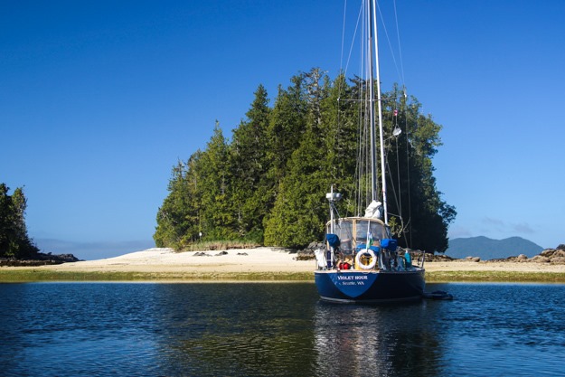
But after that it was back to the Central Coast, which we love and provided some nice easy sailing days plus 4 days at the beaches of Pruth Bay. We had fun spotting all the R2AK (Race to Alaska) boats and rounded Cape Caution under sail this time. We explored the wildlife rich anchorage of the Walker Group and then finished the month in Port McNeill for a couple days.

Continue reading

Southbound on the Central Coast of BC

After our harrowing passage across Hecate Strait in a gale, we were ready for some easy sailing days. We landed in St John Harbor of Milbanke Sound, and spent a rest day cleaning up the boat of salt and everything that got tossed around.

We then sailed to Shearwater, having a fantastic downwind sail in sun and 15-20 knots of wind. It was just what we needed after the awful Hecate passage in terrifying waves. We anchored by Shearwater and were shocked at how hot it is here – apparently summer is on the Central Coast of BC! The fleeces and cold-weather gear we wore in Haida Gwaii were replaced with shorts and t-shirts.

IMG_5824

IMG_5854

Continue reading

Passage from Hell: Crossing Hecate Strait from Haida Gwaii to Milbanke Sound

As the roar of the breaker came up behind my shoulder I looked back to see green water curling towards our stern. *Boom!* The wave smacked the side of the hull. In the next instant the wave top crashed into the cockpit, sending gallons of cold water over me and immersing my feet ankle deep.

My jacket, pants and sneakers were drenched, and the water slowly drained. No time to worry about that though, as I steered to ride the wave down. This wasn’t the first breaker we’d had that day but it was the one that caught us the worst.

It was June 15 and we were crossing Hecate Strait from the south of Haida Gwaii to the Central Coast of BC. With a forecast of NW 20-30 we thought we’d have a tough but manageable day, but ended up having a steady 30-35 knots and 6 to 14 foot waves at a 6-7 second interval (very short interval, with confused tidal interactions in some places).

Apologies that I don’t have many pictures, but conditions were way too difficult to spend time doing photography. All photos except for one were taken before 10am, in the relatively easier conditions.

IMG_5793

Sailing into the sunrise, 6am. The best sailing of the day was done by 9am!

Stats

    • Hours: 18 1/2 hours; June 15 2018, 4:30am – 11pm

      Sailed: 17 1/4 hours, Motored: 1 1/4 hours

    • Straight-line distance: 90 nautical miles
    • Distance covered: 104 nautical miles

      Covered under sail: 97 nm, Covered by motor: 7 nm

  • Wind range: NW 5-15 (10% of passage), NW 15-25 (5% of passage), NW 30-35 (80% of passage), NW 20-25 (5% of passage)
  • Wave state range: 3 ft (near Haida Gwaii), 6 ft, 9 – 12 ft, confused tidal interactions, confused swell + wind wave interactions.
  • Waves as measured by South Hecate buoy: 2.3m (7.5 ft) significant wave height at 5:30pm, 6 second period. Maximum zero crossing wave height 4.3m (14 ft).
  • Sail configurations: full sails (main + 135% genoa), reefed main + full genoa, double reefed main + full genoa, double reefed main + double reefed genoa, double reefed main + staysail, staysail alone, double reefed genoa alone, full genoa.
  • # Sail config changes: 9
  • Autopilot usage: ~40%; 8-12 hours of hand steering
  • Boats seen: 1 (cargo vessel)
  • Seasickness preventatives: Patrick: Sea-bands, 1 Bonine; Natalie: 1 Bonine
  • # of times we wished we were someplace else: Too many to count
Screenshot_20180615-230100

Route across Hecate Strait (purple line is the rhumbline – straightest course – and yellow is our actual course). We initially stayed close to the rhumbline or headed up above it (because we knew building winds would force us more downwind). The part where we were forced off the rhumbline was mostly 30-35 kts with staysail alone, and the turn where we pointed more northeasterly is where we decided to try to make Milbanke Sound.

Continue reading

Sailing Gwaii Haanas National Park

Gwaii Haanas is a protected area of Haida Gwaii, encompassing hundreds of small islands, forested mountains, and the Haida heritage sites. Few cruisers visit it, because of the time and effort of getting across Hecate Strait. We were pretty excited to be heading there after waiting out 5 days of gales in Sandspit.

The highlights for us were the beautiful hot springs at Hotsprings Island and SGang Gwaii (a UNESCO world heritage site with amazingly well preserved poles).

IMG_5778

Continue reading

Our Rainwater Catchment System

While cruising for extended periods in remote areas, refilling our water tanks is often the limiting factor in how long we can go between marinas. We’re a “water light” boat, with only a 29 gallon tank plus about 12 gallons in jugs on deck. This easily lasts us 1 1/2 to 2 weeks on our water-light budget (using about 3-4 gallons per day).

Our 41 gallons is far less than most long-distance cruising boats carry though – on the order of 75 to 150 gallons. Our boat was originally equipped with 75 gallon capacity, and I thought I’d have to add back one of the removed water tanks, but we’ve found it not to be necessary. More water adds a lot of weight, takes away storage space, and decreases sailing performance – a priority for us.

But sometimes we want to go a bit longer between marinas, such as when cruising from the North Coast of BC to the south of Haida Gwaii, areas with no convenient marinas. Some boats buy expensive watermakers which are infamous for being a maintenance headache. Here in the Pacific Northwest though we have a free, frequent source of pure water – rain!

For a while I’ve thought it’d be great to be able to catch some of it, but it’s not as simple as it seems. The main problem is catching a lot of it, and getting clean water that is free of salt (our decks are usually covered in salt) and other contaminants.

During three days this May holed up in Clark Cove while a gale blew through, bringing near-constant rain, I tried out a few improvised ideas, using only what we already had on the boat.
IMG_5546
Continue reading

Haida Gwaii Roadtrip: Pesuta Shipwreck and Tow Hill

After arriving in Skidegate Inlet, the center of Haida Gwaii and the biggest port area, we quickly realized road tripping with a rental car would be the best way to explore Moresby Island. Moresby is the north big island of Haida Gwaii, and it doesn’t have many good anchorages. For our sailing style, Moresby is best explored by car.

We rented a car in Queen Charlotte City for two days and focused on the phenomenal hikes and beaches. The first day we drove north to Masset, doing the Pesuta Shipwreck trail, the Tow Hill hike, and having dinner at Charters in Masset. The second day we stayed more local, driving just to Skidegate for the Spirit Lake trail, the Haida heritage center, coffee at Jag’s cafe, and stocking up with provisions at two of the grocery stores.

IMG_5617
IMG_20180603_093542
Continue reading

Guide to Skidegate Inlet, Haida Gwaii

After our overnight passage across Hecate Strait we were very grateful to be in Haida Gwaii, but dead tired. We spent the first day just sleeping and recuperating. The next morning dawned sunny and windless in Skedans Bay, so we set up the dinghy and motored over to the Haida heritage site at Skedans point.

The Skedans site is where a settlement of Haida people originally lived, and a number of totem poles still remain, slowly being reabsorbed into the earth. We were fascinated by how spruce trees used the cedar longhouse posts as nurse logs – you could see a huge healthy spruce tree enveloping the remains of a cedar log.

IMG_5577

The two caretakers (watchmen/women) gave us an hour-long tour of the site, telling us of Haida history and traditions. It felt special seeing history in person rather than in a museum. It was clear they continue to treasure their cultural history. It would’ve been great to stay longer, but we had plans to move to Skidegate inlet that afternoon.

IMG_5578

A ceremonial pole – each notch indicates a potlatch that took place.

Continue reading

Stuck in Skidegate Inlet – Bad Conditions on the Sandspit Bar

We’ve been in Skidegate Inlet for a week and a half now – some of that intentional, but for the last 5 days we’ve been waiting for a weather window to get out.

It’s difficult having the patience to wait for the right weather conditions. The hardest part is not knowing when we’ll be going. Conditions and forecasts are changing daily, and each time we get optimistic by a good forecast, our hopes are dashed when a new southerly gale moves in.

The challenge to getting out of Skidegate Inlet is that it has a long shallow bar and it’s near the shallow portion of Hecate Strait, which kicks up very steep waves with only a moderate amount of wind. It has no anchorages of refuge to the north (nowhere to run downwind if we get stuck in a southerly that is too strong), and the closest anchorage to the south is about 50-60 miles – a long run if you’re going upwind.

Screenshot_20180531-195520

Continue reading

Month 2 Cruising Summary: Sailing from the Octopus Islands to Haida Gwaii

When cruising for a long time, there’s a risk of becoming jaded – after countless beautiful anchorages and waterways ringed by snow capped mountains, eagles calling overhead, it can start to feel the same. When this starts to happen I remind myself how lucky we are to be cruising in one of the best areas of the world, and any jaded feelings quickly fall away.

Even though we sail through a seemingly repetitive slideshow of evergreen forests, panoramic vistas, sea life, mountains, and pristine water, there’s always something new happening to break you out of any affectation of beautiful monotony. Perhaps a rare clear night where you see more stars than you’ve ever seen in your life. A humpback quietly surfacing near your boat, or a riveting downwind sail.

The cruising life has its hard moments, but it’s rarely boring. While cruising we’re more connected with nature than we ever were in the city. It feels like long ago that we cast off the lines from our live-aboard community at Shilshole, but it’s only been two months.

In month one, we traveled from Seattle to the Octopus Islands near Campbell River, BC. In the last month, we’ve come a long way: from the Octopus Islands to Haida Gwaii.

We relaxed in the Octopus Islands, got lucky with a fantastic quick passage of Johnstone Strait, hung out in the Broughtons for a bit, and then rounded Cape Caution. Going around Cape Caution was hard, but then we had awesome, easy sunny days on the Central Coast.

From Shearwater we headed up the North Coast of BC, and had a very rainy 3 days stay at Clark Cove waiting out a gale. Our luck with wind ran out and we had a slow, frustrating crossing of Hecate Strait to Haida Gwaii.

May Route Summary-OpenCPN

Approximate route (follow the blue line).

Continue reading

Overnight Passage to Haida Gwaii

Sailing to Haida Gwaii from the north coast of BC has involved a lot of planning. In many ways it’s the most challenging passage we’ve undertaken, so we had a good deal of anxiety over it. It’s about 80-100 nautical miles – not much at all to ocean sailors, but a lot for us in the Pacific Northwest where we can generally go just 20-40 miles between anchorages.

Most boaters consider it merely a long day of motoring, so our anxiety may seem silly, but we didn’t want to motor across, we wanted to sail. 80 miles of motoring is nothing to a motorboat, but to us it’s a ton – more than we’ve motored this entire month. And Hecate Strait isn’t a simple body of water – it’s a large strait with complex currents, shallow areas, shoals and differing weather conditions from one side to the other.

So the hope was to sail, but in the end that goal was mostly a failure.

[This post covers May 30-31, 2018]

IMG_5563

View of Campania Island from Hecate Strait.

Continue reading