Monthly Archives: June 2016

Our Trip to Princess Louisa Inlet

I wasn’t going to write about Princess Louisa because the saying is that everything that could be written about it, already has been. Perhaps that is true, but I’m not so sure. Primarily this will be a pictorial post, so skip to the end if you just want the photos.

IMG_2900

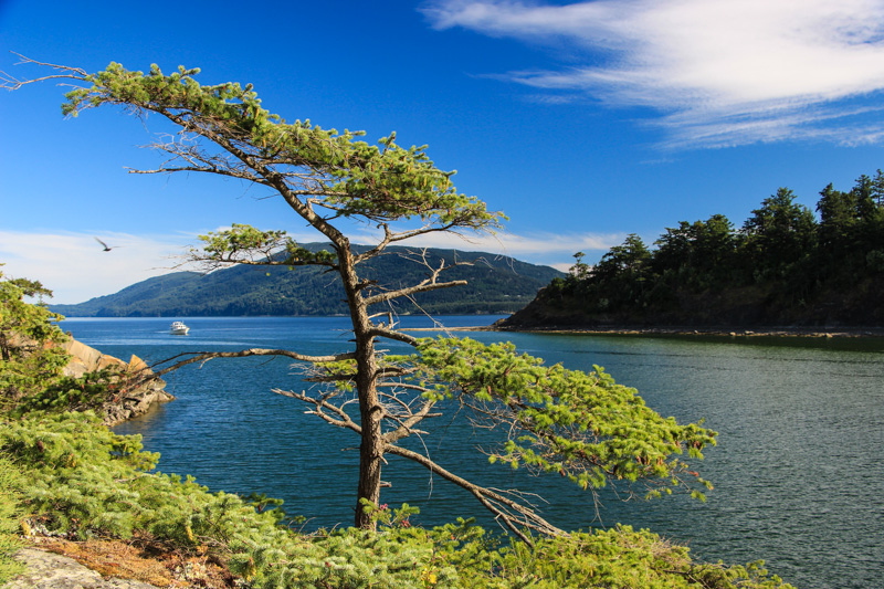
It might sound like blasphemy, but for us Princess Louisa wasn’t the heaven-like wonder some had described it as. Maybe it was because we had low cloud cover (~1000 foot level) and never saw the full experience. But we didn’t think Princess Louisa was fundamentally different from many of the other cruising destinations we visit in BC. There are a ton of off-the-beaten track anchorages with amazing scenery and a special connection with nature. This is what cruising is all about. Princess Louisa was simply another version of that – perhaps scaled up by a degree.

Continue reading

Crossing the Strait of Georgia in a Southerly

As the waves settled out a bit from their previous roar, we said (for the fourth time), “Things are looking better now.” No sooner had we said that than another series of rollers came along. The boat rolled from toerail to toerail. We could hear the wave coming by the roar of the breaker. Breaking waves don’t normally happen outside the ocean, but minor ones do happen when you have 3-4 foot waves at 3 seconds.

Each time bigger waves hit our stern quarter, the wave crest would push the boat’s stern, causing us to start to round up – in 20 knot winds. So I have to anticipate every wave and react quickly and forcefully with steering. As a wave lifts us up, the boat surfs and we drive down it. We’re doing 7 knots at times, under a single reefed main and no foresail.

We were in the Strait of Georgia – a seemingly routine waterway east of Nanaimo – heading from Porlier Pass in the Gulf Islands to Pender Harbor, on Tuesday. We knew we’d have a flood current with a southerly wind – two good things, since you want wind following current, and the wind here is usually not southerly, but southerly allows us to sail downwind which is much easier than upwind in choppy waves. We expected a downwind sleigh ride. But it wasn’t working out as well as hoped – high wind is manageable, but the short steep swell was an issue.

DCIM100GOPRO

Easy sailing – We began the crossing with 10 kts, on a broad reach

Continue reading

Hiking Mt Norman Leads Us To A Panoramic View of the Gulf Islands

As we huffed and puffed up the steep climb, we said to ourselves, “This had better be worth it!”  It was only a 1.8 mile (2.9 km) hike – 3.6 miles roundtrip –  but with 800+ feet (266m) elevation gain, and we hadn’t done any real hikes in a while. It was hot out, and we hadn’t brought enough water – from the San Juans we’d grown used to island hikes being short and easy.

Mt Norman is on South Pender Island, our first stop in Canada after crossing the border from Friday Harbor on Sunday. Our Nexus passes had made customs checkin a breeze – we called in, got our clearance number, and did a touch-and-go on the customs dock (if there are no customs agents, with a Nexus checkin you don’t have to stay).

As we rounded the last corner of the hike, we came to a viewing platform with a 180 degree view of the Gulf Islands stretching out before us. It was a beautiful day, and all I could think was wow, the hike was definitely worth it! The photos don’t really do it justice because unfortunately I can’t stitch together my panoramic photos since I forgot to download a panorama program before leaving Seattle, and don’t have Internet in the South Pender anchorage.

IMG_2838

       IMG_2851

Continue reading

Tricky Anchoring at Patos Island, San Juans

This week we’ve felt like we were running before the storm – the weather forecasts have often been pretty pessimistic. One forecast was for “rain, 15-25 knot winds, possible thunderstorms, and a chance of hail.” But somehow we’ve managed to do short sails between islands in the gaps between bad weather, and the weather also hasn’t been as bad as forecast (no hail or thunderstorms).

After Sucia, we spent a night at Patos Island and then moved on to Prevost Harbor at Stuart. More on those below.

IMG_2795

The postcard perfect lighthouse on Patos Island

Continue reading

Matts Matts Bay and Watmough Bay

In the last three days we’ve gone from Seattle to Matts Matts bay, to Watmough Bay in the San Juans, and then on to Sucia Island. We had forgotten how amazingly beautiful the San Juans are – they really are a Washington state treasure. Everywhere we look are scenic mountain ranges, evergreen covered islands, blue skies (sometimes), and wild life. Our journey is only just beginning, but it already feels like we’re a world away.

From a sailing perspective the most amazing part is we’ve sailed most of the way and haven’t had to sail upwind even once – when there has been wind, it’s been at our backs. We’ve been riding a wave of southerlies north. That hasn’t meant it’s been easy – there have been a few challenging times as we’re getting back into the routine of cruising.

IMG_2777

Looking out on Fossil Bay on Sucia Island

Continue reading

Casting Off The Lines

Today we cast off our dock lines and leave Seattle for three months. This day is something we’ve looked forward to for a long time. The trip will be a true adventure. Maybe more adventure than we’d like. Last year we found the adventure we dreamed of was not the adventure we seek.

We don’t know yet what we’ll find. But if we knew every challenge we’d face, it wouldn’t be an adventure.

IMG_1942

It would be far easier not to go. It would be more comfortable and less scary to sit on our couch drinking beer and watching Game of Thrones on Sunday night. Our jobs pay the bills, and it’s difficult to give that up, if only temporarily. It would be far more comfortable sitting in an air conditioned office each workday rather than grinding winches, battling wave spray sailing upwind, and repairing a diesel engine. But that isn’t the life we want to live all the time.

Continue reading