Category Archives: cruises

Sailing in Southeast Alaska Compared to British Columbia and Washington

When we set sail for Alaska in late March, on an 18-day quarantined transit of British Columbia, we knew we’d find adventure in Alaska. But we didn’t know we’d fall in love with it. After 5 months of cruising Southeast Alaska, the mountains, wildlife and fishing have impressed us enough that we’re not sure we’ll want to leave. (And we’ll be living on our boat in Juneau for the winter, so that we’re already positioned for a full season here next spring/summer).

Since this was our first time sailing Alaska, and we spent 5 out of the last 6 seasons in British Columbia (which we formerly considered our primary cruising region), naturally many thoughts turn to comparisons of Alaska vs southern waters (BC and WA). I haven’t blogged much about our time here (focusing on Instagram) but figured a summary of our learning experience might help other cruisers looking to come here.

Cannery Cove, Pybus Bay

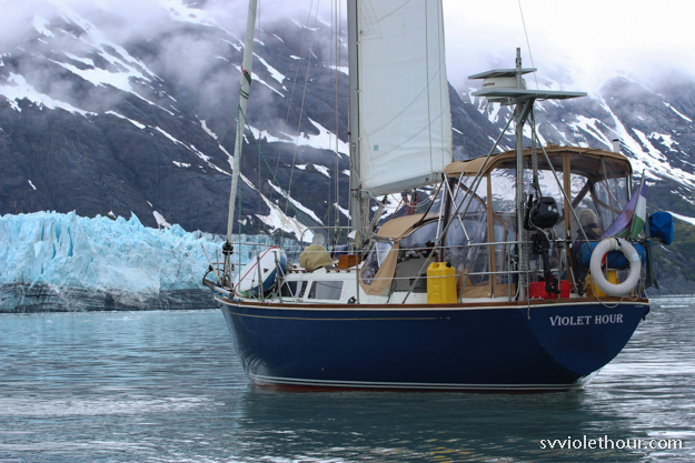
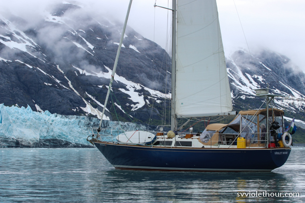
Margerie Glacier, Glacier Bay National Park

Alaska is a tough place to cruise, and the highs and lows are more extreme, but the rewards can also be greater. Some differences (the good and the not-so-good) standout with Alaska:

Continue reading

Sailing Glacier Bay in Early June: Tough Weather but So Much Wildlife

Glacier Bay National Park, at the northern edge of southeast Alaska, is a capstone destination for many cruisers. We spent 9 days there in late May / early June and had pretty much the worst weather luck you could possibly have. Near constant rain every day, cold, fog, dense clouds obscuring the views, low visibility and little wind (so the sailing was usually poor). And yet, it was still awe inspiring. That kind of tells you how special of a place Glacier Bay is.

It’s the most alive place we’ve ever been. Much like the rest of Alaska, but more. Wildlife that would be a rare sighting in other places is an everyday occurrence here. We saw sea otters and humpbacks pretty much every day, and orcas on several days. Everyday was different, and seeing first-hand the uniqueness of this area made it clear why it’s protected.

We can only imagine what it would be like in sunny weather. Weather impacts perception of a cruising destination immensely. We learned that early in our cruising learning curve when we went to Princess Louisa Inlet and were thoroughly underwhelmed by a lot of motoring and poor views – the mountains were obscured by low cloud cover and rain the entire time. It’s possible to be passing towering mountains and have it look about the same as Tacoma Narrows on a foggy day – with low cloud cover you’d never know there are 2000 foot cliffs and 8000 foot peaks around you.

Glacier Bay was different though. Despite terrible weather, it was still worth it. In fact, the adversity of the weather made us appreciate it all the more in the brief moments when the mountains came out.

Continue reading

Washington to Alaska in 18 Days (With No Shore Leave!)

We made it to Alaska! 18 days. 650 nautical miles. 195 of that motoring and 455 sailing (70%). We stepped off the boat only once, for fuel in Port McNeill. It was the most challenging trip we’ve ever done, made more challenging due to thru-transiting restrictions and the early season. We had sun, rain, snow, graupel storms, high winds, and at times rough seas. The early season meant we usually had plenty of wind, enabling us to sail fast and minimize motoring. Though we had some very tough days, our past years of experience along three-quarters of the route helped a lot.

We were allowed into Canada as a marine thru-transit because we were moving our home to Alaska for residency, and were not allowed to get off the boat or sightsee. We anchored each night to rest (and because it’s unsafe to travel the Inside Passage at night with the hundreds of logs/trees we had to dodge). And we were allowed to stop for fuel, water, or groceries which we did once for only fuel and water. We also were told to get through as quickly as possible – the Canadian customs main priority seemed to be ensuring that no tourism happens.

Needless to say there was no tourism, as we were already motivated to go as quickly as possible. We were dead tired each night and spent our days in transit or fixing issues on the boat.

It’s about 600-700 nautical miles to Alaska from Friday Harbor (where we started in the San Juans) but this distance is deceptive – it feels much longer than that because there are dozens of different weather systems, tidal gates, and sailing challenges to go through. Every day is different, and the wind comes from all directions. One day you might have a southeast gale followed by a northwest gale the next day (as happened around Campbell River).

Going to Alaska this quickly is not what we’d call fun. It was one challenging passage after another, with no break in between and none of the typical rewards of cruising (visiting ports, hiking on shore, water activities like paddleboarding, crabbing / fishing, etc).

A small graupel shower while sailing up Petrel Channel

Continue reading

A Trip Around Whidbey: Circumnavigating the Largest Island in Washington

Circumnavigation is a term typically used for rounding the entire globe – but it can also be used for simply rounding an island. Boaters here often say they circumnavigated Vancouver Island, because that’s a significant accomplishment – Vancouver Island is a very large island. It would be perhaps a bit silly to say you circumnavigated a tiny island, like Blake Island, though.

Since we’re lacking in challenges now due to Canada being closed, we had the idea of circumnavigating Whidbey Island just for the fun of it. And it turns out Whidbey is actually quite a large island – the largest island in Washington and the longest island on the entire US mainland west coast (BC and Alaska have longer islands, but this is the largest one we can get to right now).

Going around Whidbey would mean we’d get to see the inside of Whidbey – including Deception Pass. This is the “inside” protected route to/from the San Juans, and one that motor boats often use. We’ve actually never been through Deception Pass though because we like to maximize sailing and were unsure about the opportunities for sailing on the inside.

Conditions were pretty bumpy in the Rosario tide rip

If I wear my Canada hat, maybe they’ll let us in? 🙂

Continue reading

Quarantine Cruising Weeks 1+2: Life on the Hook

We’re one to two weeks into quarantine cruising, and not really cruising as much as just living at anchor. We “cast off” this year on March 20, a little earlier than normal – accelerating our plans due to the coronavirus spread in Seattle.

In the cities, the fear and anxiety was palpable. Now that we’re out on the water, that’s fading away – routine on the water is ruled more by weather than the news cycle. Outside, nature is still proceeding as normal. The sea is still the sea, the birds still the birds, seals still seals.

After finishing our haul-out on March 20th, the choice was between either living at anchor (“on the hook”) or in a marina where we’d be crowded closer to many more people, having more surface contacts and also paying a lot more for moorage. For these reasons the choice was easy – we like life on the hook anyway.

A few things have made it more difficult this first week though: weather (cold and rainy – it’s still March after-all) and the closure of WA State Parks (to all uses including hiking), and the San Juans to all transient overnight moorage.

We had planned to spend a week at Blake Island, but the closure of WA State Parks threw out that idea. That was a big loss because Blake Island is one of our favorite places and has great hiking for exercise in dutifully socially distanced manners (we usually see more deer and raccoons on the trails than people).

Continue reading

Transition to Winter: Slowing Down, and Finding Balance between Sailing or Not

It’s been a bit over a month now since we stopped full-time cruising (after being at anchor 95% of the time for 6 months!) and holed up in a marina for a break. I know there are some sailors that spend northwest winters at anchor, hopping around, but honestly that seems really really tough.

Fall seemed to arrive fast and furious this year, bringing surprisingly strong early southeasterlies and pretty regular rain. Some people are saying that fall lasted only one week, because by early October we already had lows of 36 F in the coastal areas and snow in the mountains. A tough time to live on a boat at anchor, even with a diesel heater.

The rainy weeks are tougher than the cold ones – when it rains for 7 days straight we rely pretty heavily on our AC powered dehumidifier to dry out wet clothes and keep the boat from growing mildew. At times the pounding on the deck seemed unrelenting.

So in the fall and winter we turn to marinas more for power and also for a break from cruising. Marina life is way easier than being on the hook. We have luxuries like unlimited power, water, and laundry machines on shore. Plus there are restaurants, so occasionally we can get a break from home cooking all our meals. Of course, these luxuries are something most people take for granted, but as sailors you learn to appreciate them a lot more.

Continue reading

Nootka to Barkley Sound: Final Legs of our West Van Isle Trip

In the last week (July 13-20) we’ve sailed from Nootka Sound to Clayoquot Sound and then on to Barkley Sound, the last stop on our trip down Vancouver Island. As we left Clayoquot Sound on July 18, summer finally showed up and we’ve had northwest winds with sun and blue skies most of the time since then. We’ve still had some rainy southerlies sweeping through about every 4-5 days, but they’re usually short-lived.

Needless to say we’re reveling in the summer sailing experience now – shorts and t-shirts, ample solar power for cold beverages, paddleboarding, swimming, and rigging up the hammock between mast and forestay.

Rounding Estevan Point: Nootka Sound to Hot Springs Cove

Getting out of Nootka Sound is always hard. The entrance to the sound is shaped like a funnel, and it funnels both wind and current at the constriction point. Westerly ocean swell tries to roll into the entrance, and with an opposing ebb current the waves can get quite steep and sharp. And going out is always an upwind sail, because the wind inflows.

Fortunately we had a pretty good day for it, with light south wind (8-10 kts) – which comes pretty much from the west until you make Estevan Point. The waves were choppy and pound-happy but we had timed our departure to near slack current so they weren’t nearly as bad as they could be.


It was a long day (~9 hours) but a fun one. We think we saw an ocean sunfish near Estevan Point. They’re a very rare creature that we’ve never previously seen. They can grow quite large and have two fins, which wave alternately above the water.

Continue reading

Windless Days and Southerlies on the West Coast of Van Isle: Strange July Weather

After passing the Brooks Peninsula on June 30, July has brought very weird and challenging weather. It doesn’t feel like summer, and we’ve gone many days not even seeing the sun, because it’s obscured behind a heavy cloud layer. We’ve had rain about half the days; normally in Seattle we count on summer arriving after the 4th of July, but that hasn’t seemed the case on the west coast of Vancouver Island.

The weather varies between chilly to warm and very humid (90% humidity). The humid days are completely overcast, darkening the sky and reducing solar output. It feels like a Hawaiian rainforest, but without the sun. Other times, the temperature has been chillier than we had a month and a half ago, in late May on the Central Coast. We’ve been wearing foulies and fleeces in July, which seems very weird.

BC weather forecasting says there’s a ridge offshore and a quasi-stationary trough over the mainland, but I don’t know if that explains things or not. Someone we met at Nuchatlitz said there’s an inversion going on, which explains things a lot better (we’re quite familiar with inversions in Seattle, but they usually happen in the spring or fall, not summer!). An inversion, as I understand it, means warmer, clearer air is stuck above a dense cloud layer. People at ground level (ie, anyone on a boat) experience dark, chilly conditions, but if you could hike up 5000 feet or so you’d get to nice sunny conditions. It also means little wind – if there were wind, it would blow out the inversion.

The lack of wind has been the most frustrating part. It’s almost like we’re in the doldrums, the ITCZ, or the South Sound in August. Our last 4 days in Kyoquot Sound didn’t have a single hour with wind over 5 knots. And when we “sailed” to Esperanza Inlet on a forecast of NW 5-15, we had to motor pretty much the whole way because there wasn’t more than 4 knots on the ocean the whole day.

Another rainy rainy day.

[This post covers July 7-12, 2019]

Continue reading

Exploring the Beautiful Anchorages of Kyoquot Sound on the West Coast of Vancouver Island

Kyoquot Sound is the second sound on the northwest coast of Vancouver Island, after Quatsino Sound, and is the place of refuge after the Brooks Peninsula. We’ve spent almost a week here, discovering some beautiful anchorages – the highlights being Columbia Cove and the Bunsby’s.

We continued to see sea otters, including the first raft (group of 20-30) we’ve spotted. And Kyoquot is the first place I’ve seen bat stars, a sea star that is black in color (almost an iridescent blackish-purple) – there were lots in the Bunsbys and also Walter’s Cove. Mosquitoes are also present in all the anchorages here, so make sure to have good hatch nets.

We spent all our time in the outer waters of Kyoquot Sound – technically not within the sound itself (Columbia Cove > Bunsbys > Walter’s Cove > Barter Cove > Rugged Point). We read that Kyoquot Sound itself rarely gets much wind, so it’s probably not a good region for sailing. The anchorages of the outer region are rugged and beautiful, with several of them having views out to the Pacific Ocean. We tend to like the rugged outer anchorages, and found they made for great exploring by dinghy or paddleboard.

[This post covers June 30 – July 6, 2019]

A bat star

Continue reading

A Perfect Sail Around The Brooks Peninsula and Cape Cook

To a sailor there’s nothing more exciting than feeling the boat power up in a strong breeze. The boat digs in to the swell and takes off, using only the power of the wind. Everything is in harmony – the rig, the sails, the rudder. At times like these one of my favorite things is to go below. Listening to the sound of water rushing past the hull always brings forth a sense of wonderment.

In a book I’m reading, “Alone Together” by Christian Williams, he puts it aptly: “To sail a boat across water using only the wind is like a miracle, every time. The wind is free and gives its gift not just to you but to the waves and the sky, the clouds and the birds, who all move with it, day and night.”

Our rounding of the Brooks Peninsula was just about perfect, and we couldn’t have asked for a better day. It was a combination of patience and luck – patience for waiting out persistent southerlies and rain, and luck that all the variables aligned. A forecast of NW 10-20, low swell state, and a warm sunny day.

The distinctive Solander Island is just a bit offshore of Brooks Peninsula, and has a wind reporting station.

The Brooks Peninsula, and Cape Cook at its northwesternmost point, jut out about 8 nautical miles into the Pacific Ocean, the largest promontory of Vancouver Island. The Brooks Peninsula is  feared and respected by mariners because it creates a powerful wind acceleration zone and also potentially confused seas from headland interactions and up to 1.5 knots of current flowing by.

Our guidebooks said that Cape Cook is the most difficult obstacle of a circumnavigation of Vancouver Island. With the ideal conditions though, it was one of our easiest sails. I can certainly imagine it being tough though – it’s common to hear a forecast for W Van Isle N of NW 15-25 except NW 25-35 at the Brooks Peninsula.

Continue reading