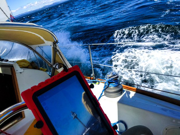
It seemed long ago, but only yesterday (July 1) we had been hoping for some more wind while crossing the Strait from Port Ludlow to Mackaye Harbor. Today, Sunday, we were bashing upwind towards Victoria, battling a small craft advisory that was soon to turn into a full-on gale. We were heeled over 20 degrees and pitching through big waves – going into the cabin to fetch lunch or use the head was an exercise in bracing ourselves nearly sideways against bulkheads and doorways.
Although the wind was “only” 15-18, 15 in the Strait of Juan de Fuca can feel like 25 in Puget Sound. The waves were the main challenge – 2-3 foot wind waves on top of swell (in some places) which had built up from the prior night of high winds, with tide rips thrown in for extra fun. To surmount these waves we had to stay powered up to crest over them and then slam down into the trough, our lee stern quarter slushing away what seemed like a mountain of water. We had a reef in the main and a reef in the genoa, closed hauled for 4 hours.
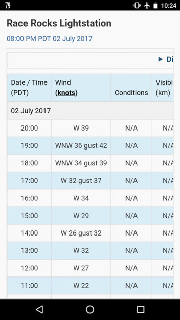
We got into Oak Bay marina about 3pm, fortunately before the gale really arrived, bringing 30-40 knot winds. Race Rocks registered 42. These summer inflow winds are throwing a hitch into our plans of getting out to the west coast, and are in stark contrast to the near windless conditions we saw in the Strait two years ago at this same time of year. It brings newfound respect for the Strait, where previously we’ve never seen more than 10 knots, in over a dozen times in the eastern Strait.

Sunday’s upwind bash through confused waves from the San Juans to Victoria.

Fortunately we weren’t at Race Rocks for this, but we worried a lot about running into it the next day.
But, while it’s disappointing to be making slightly slower progress, it fits with our deliberately slow pace of cruising, and delaying our Strait exit is actually the prudent move – Sunday night is the peak of the gale inflow, so we wouldn’t want to be anywhere near Race Rocks at that time.
Mackaye Harbor, Charles Island (Lopez)
The prior day, Saturday, we had a typically slow, frustrating crossing from Point Wilson to the San Juans – 6-8 kt W-SW winds with largish swell which was difficult to overcome while sailing with only 6-8 kts. However, the tide was in our favor and we managed to sail most of the way. We had hoped to get to Victoria this day, but the lack of wind ended up ruling that out.
We tried a new anchorage behind Charles Island, between the two underwater cables, which was very scenic and well protected from the wind. Eagles called overhead from their tree-top perches. The spot was a bit less protected from waves – sheltered from all direct swell from the Strait, but there was a small amount of wave refraction which was enough to keep our boat unsteady and rolly-polly all night. I suspect a calm night would be fine, but the Strait was blowing 15-20.

Sunset in Mackaye Harbor
Monday – Trials and Tribulations at Trial Island
Jumping forward to Monday, we departed Oak Bay marina at 9:15am and set sail for Becher Bay. The wind was at 6-8 SW, some unusual morning wind that carried over from the last night’s gale. But, as we approached the point off Trial Island (east of Victoria’s Inner Harbour), we were getting pushed by a flood current which was far stronger than expected. We got carried out into the shipping lanes and then tacked back, ending up at the exact same place we had been over 1 hour ago! More than an hour of sailing for nothing.
It was at this point I figured out the nearest current station which predicted 0.7 kts was not accurate at all for Trial Island, and we were fighting a 4 knot flood. We had to motor past Trial Island, making frightenly slow progress (closing monitoring the rocky point to make sure we didn’t get pushed into it).

Trying to sail past Trial Island with a SW wind. The leg due west is motoring, and everything else is sailing (in terrible current).
In the end it took us about 8 hours to sail 17 nm (distance measured as the motor boat travels). The winds picked up around Race Rocks fortunately (as expected for that area), but to a manageable 14 kts.

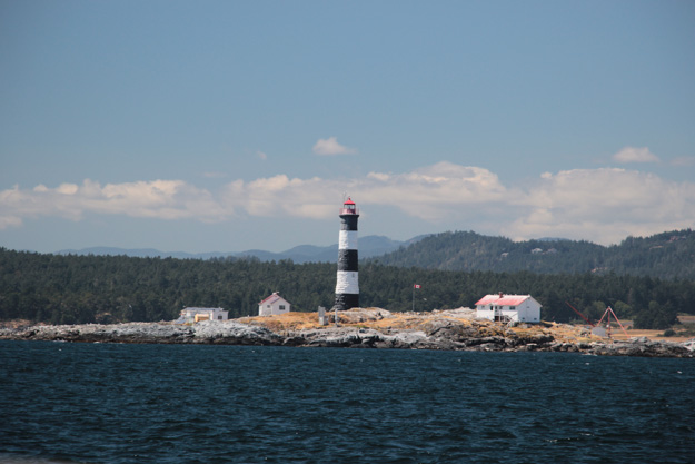
Race Rocks Lighthouse
Adverse Currents and Waves
I’ve really been hoping to sail at least some of our trip out the Strait this year, but it’s discouragingly challenging. A big problem of exiting the Strait early July, while also wanting to sail, has been the terrible timing of the ebb. The super ebb (the larger of the two) happens about 3am – 9am, and the smaller ebb is about 3pm – 8pm. So the super ebb is during the worst sailing hours (but the best motoring hours) and the small ebb is late enough that it coincides with potentially gale force inflow winds, and with very late arrival to an anchorage. Sailing into 25 kts with two crew is very quickly exhausting, plus it’s a wind against current situation.
Another frustration has been that the flood current (about 9-3pm) has often been double what the predictions say it should be. Although the current tables in Navionics say this is a weak flood (0.7 kts peak at Pillar Pt), we experienced over twice that (2 kts opposing). I’m not sure why this is, but am guessing that the strong inflow winds caused by the NW-SE oriented high pressure ridge (with low pressure in the Cascades) can actually amplify the flood.
The waves in the Strait of Juan de Fuca have also been unusually large for the summertime. Tuesday from Becher Bay to Port Renfrew, we had 6 foot waves at 7 seconds in the western strait (according to the Neah Bay buoy – I would say our average waves were 4 feet, but peak were 6-7 feet – and we weren’t exactly at the Neah Bay buoy).
The waves in both the western Strait and eastern Strait have been bad enough to make me feel a bit queasy, and I don’t easily get seasick. Natalie has been using Seabands and took some anti-seasickness pills.

Sailing upwind to Race Rocks, in 10 building to 15

View of Olympics from Becher Bay
Tuesday – Becher Bay to Port Renfrew
We woke up at 5:45 to catch the 2nd half of the super ebb at 6am. Since it was so early, that meant motoring for several hours (0-2 kt wind). But we had a 2 knot push the first hour, then 1.5, then 1, till eventually no push and a bit of adverse current.
Sailing Through Fog
About 11am in the western Strait, 6 nm from Port Renfrew, some wind filled in – 6-10 W. So we set sail tacking upwind, and soon entered the fog bank we had been approaching. Sailing through fog at 5-6 knots and 6 foot waves was incredibly disorienting. Since you can’t see the horizon (we had less than 1/4 mile visibility), it’s very easy to get seasick. If I closed my eyes a moment, I’d often open them staring into the face of a giant wave approaching our bow.
Unfortunately due to the flood again being twice as strong as predicted (1.5 against instead of 0.7), tacking upwind the 6 nm took 2 hours. But as soon as we cleared the point to Port Renfrew, we had a fun downwind sail into the harbor, soaring through the fog bank and emerging in sun. The wind was at 15 now and a fair amount of wave chop / fetch makes it into Port Renfrew, so we carefully selected the calmest location sheltered behind the marina breakwater. It was a bit rolly when current turned us sideways to the waves, but otherwise was fine. A Customs boat came by to check our clearance number.

Sailing through dense fog and 6 foot waves in the western Strait

Wednesday – Port Renfrew to Barkley Sound
Wednesday we awoke to more fog – Port Renfrew was socked in, but some wind started around 9:30 and we had hopes it would blow out the fog, so we headed out, with the radar running to watch out for fishing boats. This is the most we’ve used our radar since buying the boat 2 1/2 years ago, and I have to admit the previously useless device came in handy today and yesterday. We had only 1/8 mile visibility at times.
Unfortunately the fog didn’t clear, and the entire western Strait up to Carmanah Point was blanketed in fog with little wind (<3 kts). The wind in Port Renfrew had been a fake-out – it funnels into the bay sometimes. We motored for seven hours, desperate to sail. Around 3pm there was 8-10 kts on the nose and after we passed Pachena Point we set sail. It was slow going though because current was also against us. Near Cape Beale we hit a wind lull and the waves started to become short and sharp, so we started motor sailing to clear the cape.
Soon the waves were 4 feet at 2 seconds, the extremely steep waves we became familiar with two years ago in these waters. Natalie was helming and, not realizing the growing close-spaced waves, buried the bow, sending gallons of water down the side decks where it sloshed around at the stern for a minute (our aft deck scuppers are small, intended for rain and wave spray). I thought it was quite funny but she was a bit concerned.
We gave Cape Beale a 1/2 nm berth, but other sailboats motoring north gave it closer to 1 nm. We were tired and wanted to get in though. We did fine, but it was easy to see how we wouldn’t have handled this well two years ago. This time I knew how to steer down the short stacked waves that were rolling into the shallows off Cape Beale. As soon as we got around it we were able to fall off and set sail with 15-18 kt winds for a fun downwind sail to Dodger Channel.

Perspective
If this sounds like all complaining, it’s not meant to be. This is cruising – sometimes you get tough days, and sometimes you get five of them in a row. We knew going out the Strait would be hard, but all this sailing and motoring to windward, into large waves, has made me at times question whether it’s really worth it. It took us 5 1/2 days to get to Barkley Sound, and I knew we could easily turn downwind and be in the San Juans, Gulfs, or Lasqueti with relative ease.
The payout will come when we get to Barkley Sound and have dozens of fantastic anchorages to choose from that aren’t 45 miles apart. It’s crazy to me though to think that there’s a race, Swiftsure, where people sail out the Strait for “fun” and then turn around, not having gone anywhere!
[Note: We’re currently in Bamfield, after a night in Dodger Channel, and it’s fantastic!]

Hope the weather gets better!
Yeah it can be pretty brutal on the JdF – funny how in summer there is either too much wind, or zero! And the huge currents are really frustrating if they don’t line up.
I found the Navionics currents just plain wrong a lot of the time. Like the direction was GENERALLY correct, but the actual speeds are wrong. The are tables online from the Canadian Hydrowhatsit services that are more accurate.
Canadian Hydrographic just has current tables for major tidal passes though, not general areas or for the Juan de Fuca. Unless there’s some other webpage I’m missing? They have tide charts for more areas, but those aren’t really helpful for currents because they don’t show the time the current switches or strength.
There’s a current table for Juan de Fuca East http://www.tides.gc.ca/eng/data/table/2017/curr_ref/1100
Honestly at this point the currents are complicated (esp around all the islands) I just figure out when the tides coming in or out and then base it around that (much as you did).
Oh, right, I missed that. East Strait of Juan de Fuca is a huge region so I dismissed that as unhelpful when I saw it a couple years ago. I agree, we end up trying to deduce the currents. I always find we’re getting it wrong more often in BC than in the US.